ST ANNS WELL ROAD PRE DEMOLITION (1970)
  • Home
    • Facebook group History
    • About & Guidleines
    • Contact
    • EVENTS >
      • 2025
      • 2024 Annual Gathering
      • 2023 Annual Gathering
      • 2022 Annual Gathering
      • 2021 Annual Gathering
      • 2018 Annual Gathering
      • 2019 Annual Gathering
      • 2017 Annual Gathering
      • 2016 Annual Gathering
      • 2015 Annual Gathering
      • 2014 Annual Gathering
      • 2013 Inaugural Gathering
      • 2017 Cinema visit "Some Like it Hot"
      • 2016 - Movie outing
    • Join the facebook group
  • Tony
  • INDEX
    • 1970s Nottingham Post
    • A VIRTUAL ART GALLERY - art by our members
    • Allotments - Hungerhill Gardens
    • Anecdotes Stories and Memories >
      • Talking 'bout - WASH DAYS - HOUSEWORK - KEEPING CLEAN ETC
      • Telling Tales
      • The Call of the Streets
      • The Weather
    • BLUE PLAQUES (Special Establishments)
    • BLUE PLAQUES (Unsung Heros)
    • Do you remember?
    • Boys Brigade & Girls Brigade
    • BB Tribute
    • Bonfire Night
    • Brownies Girl Guides Cubs Scouts etc
    • CHRISTMAS
    • Central Market
    • Cinema - Cavendish
    • Cinema - The Empress
    • Coppice Rec
    • Dance Halls in Nottingham
    • Dance HallL Palais de Danse
    • Downloadable Files
    • External Links-
    • 'Famous' >
      • Speedway - Fred Strecker
    • Fish and Chips
    • GAMES - snobs, hopscotch, buttercups, balls, skipping
    • GARDEN OF REST >
      • Harry Taylor
    • Hopewells
    • INTERVIEWS & STORIES >
      • Albert Spooner - The Place Where I Lived
      • Sistino Rao
      • Steve Bloomer
      • STORIES FROM ALAN DURY
    • Lace
    • 'MAPS'
    • Mr Salt - Board School Headmaster
    • Member Walks
    • 'Poetry' >
      • Poetry by Jean Taylor
      • Poetry by Geoff Freeman
      • Poem by Sid Wheeldon
      • Poetry by Chris Moore
      • Poetry by Bruce Lakin
    • Pownall
    • Press Clippings >
      • transcription1
    • Ray Gosling
    • Ruth I Johns (author Inner City Voices"
    • School Days The Happiest Days of your Life
    • Shops etc
    • St Ann's Well
    • Sneinton Market (Bath St)
    • Sound Bites
    • Trolley Buses
    • The Library
    • The Lost Generations by Paul Henson
    • What was "the demolition"
    • Wedding Day
    • Work
  • STREETS
    • STREETS directly off St Anns Well Rd
    • STREETS listed aphabetically
    • Abbey Grove (The Wells Rd to Richmond Ave)
    • Abbotsford St (off Corporation Road)
    • Abbott Street
    • Ada St (Meredith St to Jackson St)
    • Alfred St Central & North
    • Alfred St South
    • Alison Rise (off Alfred St Central)
    • Alpine Tce
    • Angrave St (off Moffat St)
    • Ash St (off Peas Hill Rd)
    • Ashforth St (off Alfred St Central)
    • Ashley St
    • Ashover Tce
    • Ball St (The Wells Rd to Blue Bell Hill Rd)
    • Bangor St
    • BATH STREET
    • Beacon St
    • Beaconsfield Tce
    • Beauchamp St
    • Beaumont Place (off Beaumont St)
    • Belle Vue Road (Northampton to Jackson St)
    • Berkeley St (off Lamartine St)
    • Beverley St >
      • Jill West nee Pettit
    • Bilberry St
    • Birkland Avenue (Peel St to Annesley Grove)
    • Blake St (Gordon Rd to Pym St)
    • Bloomfield St (off Dame Agnes St)
    • Bluebell Hill Road (off Alfred St South)
    • Bombay St >
      • Mick & Connie Newton
    • Bowers Ave (Woodborough Road to Park Ave)
    • Bracton Drive (Gordon Rd Estate)
    • Brighton Street (Peas Hill Rd to Robin Hood's Chase) >
      • Angie Miles nee Cundy
    • Broad Oak Street (Corporation Rd to St Ann's Valley)
    • Brook St
    • Bullace Road (off Bilberry St)
    • Bullivant St (off Alfred St Central)
    • Burgass Tce
    • Burton's Yard
    • Bycrofts Yard
    • Calcutta St
    • Campbell Grove (off Hawkridge St)
    • Cardiff St
    • Cardinal St and Cardinal Tce (off Calcutta St)
    • Carnarvon Street (Woodborough Rd to Marple St)
    • Caroline St (Peas Hill Rd to Abbotsford St)
    • Cathcart St >
      • Maureen Barker
    • Central St (opposite 29 Northampton St)
    • Chadburn St (off Dame Agnes St)
    • Chandos St (Cromer Rd to Hungerhill Rd)
    • Chaucer Tce (off Harlaxton St)
    • Clarence Street (off Carlton Rd)
    • Coalpit Lane
    • Colborn Street (The Wells Rd to Blue Bell Hill Rd)
    • Commercial Square
    • Comyn St (off Great Freeman St)
    • Conway St
    • Cooper Street (Alfred St Central to Peas Hill Rd)
    • Copestakes Yard
    • Corporation Rd
    • Courtnay Tce (off Westville St)
    • Cranmer St and Cranmer Grove
    • Cromer Road (Ransom Rd to Hungerhill Rd)
    • Cromwell Tce off Alfred St
    • Crown St (Bluebell Hill to Flewitt St)
    • Curzon St
    • Dame Agnes Street (Woodborough Rd to Corporation Rd) - inc Dame Agnes Tce
    • Dane Street (Alfred St Central to Peas Hill Rd)
    • Darby Tce (off Lotus St)
    • Daykene St
    • Dennett St (Flewitt St to Wright St)
    • Dickinson St
    • Dover Tce (off Lotus St)
    • Dowson St (Blue Bell Hill to Gordon Rd)
    • Duncombe St
    • Eastville St (Peas Hill Rd to Northville St)
    • Edgar Rise (off Peas Hill Rd)
    • Edwin St >
      • Tony Miller
    • Egerton St (St Ann's Hill to Bangor St)
    • Elm Grove (Off BlueBell Hill Rd)
    • Enoch Tce
    • Fairhome Tce off Storer St
    • Ferrers St
    • Festus St (Eastville St to Westville St)
    • Flewitt St (Alfred St South to Young St)
    • Ford St St Mary
    • Franchise Terrace (off Westminster St)
    • Frederick Tce
    • Freeman St
    • Fyne St
    • Gerald Ave (Off Martin St)
    • Garnett St (off Gordon Rd)
    • Girsby Tce (off Pym St)
    • Gladstone Street St Mary (Alfred St Central to Palmerstone St)
    • Glasshouse St (Lower Parliament St to Union Rd)
    • Glenroy Tce (Opposite Manning St)
    • Gordon Road (Lowdham St to Bartholomew Rd)
    • Great Eastern St & Tce (off Alfred St Central)
    • Great Freeman St (Huntingdon St to Alfred St Central)
    • Guys Terrace (off Blue Bell Hill Rd)
    • HANDEL ST
    • Harcourt Tce (Lamartine to Scarborough St)
    • Hardy Tce (off Simkins St)
    • Harlaxton St (Woodborough Rd to Heskey St)
    • Hartwell St (Truman St to Peas Hill Rd)
    • Harvey Tce (opposite Monk St)
    • Havelock St
    • Hawkridge St (Campbell Grove to Alfred St South)
    • Hawksworth St (Storer St to Clarence St)
    • Heath's Tce (off Lotus St)
    • Hedderley Street (Union Rd to Great Freeman St)
    • Hendon Rise (off The Wells Rd)
    • Herbert Street (Eastville St to Westville St)
    • Heskey Street (Huntingdon St to Alfred St North)
    • Hogarth St
    • Holly Gardens (Thorneywood Mount to Marmion Rd)
    • Howard St (Glasshouse St to Huntingdon St)
    • Hudson Street (Blue Bell Hill Rd to Gordon Rd)
    • Hungerhill Road (Corporation Rd to Ransom Rd)
    • Hunt Street (Blue Bell Hill to Gordon Rd)
    • Huntingdon St (Alfred St North to Mansfield Rd to Lower Parliament St)
    • Hutchinson St (Northumberland St to Alfred St Central)
    • Independent Hill
    • Jackson St
    • Jackson Tce (Off Simpkin St)
    • Kebir Tce
    • Kelham Green
    • Kemps Cottages (Lowdham St to Carlton Rd)
    • Kilbourn St
    • Kildare Rd
    • Laburnum St (Dame Agnes St to Sycamore Rd)
    • Lamartine St >
      • letter lamatine st
    • Laurel St (Dame Agnes St to Sycamore Rd) and Laurel Tce >
      • BRIAN ARAM
    • Lavender St (off Dame Agnes St)
    • Leeson St (off Great Freeman St)
    • Leicester St
    • Leighton St
    • Lewis St (Alfred St Central to Peas Hill Rd)
    • Lilac St (Dame Agnes St to Sycamore Rd)
    • Lily St (Dame Agnes St to Sycamore Rd)
    • Lime Tce
    • Linden St (Dame Agnes St to Sycamore Rd)
    • Little John St (off Peas Hill Rd) & Little John Tce
    • Livingstone St
    • Lomas Street off Hungerhill Rd
    • Lorne Grove
    • Lotus St
    • Loverseed Tce and Loverseed Vale
    • Lowdham St
    • Ludlow Tce (Dame Agnes St to Corporation Rd)
    • Lupin St
    • Luther Ave (Martin St to Leicester St)
    • Lytton St (off Gordon Rd)
    • Manchester St
    • Manning Grove (Manning St to Robin Hood Chase)
    • Manning St (Woodborough Rd to Trevitt St) >
      • Richard Pykett
    • Manning Tce (off Abbotsford St)
    • Mansfield Road
    • Marple Street (Alfred St North to Cranmer St)
    • Martin St
    • Massey St (Blue Bell Hill Rd to Gordon Rd)
    • Mellers St (Dame Agnes St to Abbotsford St)
    • Meredith St
    • Moffat St (Southampton St to Pym St)
    • Monk Street (Blue Bell Hill Rd to Gordon Rd)
    • Mornington St (Wellington St to Woodborough Rd)
    • Mowbray St (Lamartine St to Ferrers St)
    • National Tce (off Westminster St)
    • Nile St
    • Norfolk Tce
    • Norland Rd >
      • Barry Taylor - Norland Rd
    • Northampton St
    • Northumberland St >
      • Barry Taylor - Northumberland St
    • NORTHUMBERLAND TCE
    • Northville St and Northville Tce (Raglan St to Woodborough Rd)
    • Nugent St (Calcutta to Bombay St)
    • Oldham St
    • Owen St and Owen Place (Gordon Rd to St Matthias' St)
    • Palmerston St (Woodborough Rd to Gladstone St St Mary)
    • Parrott Place
    • Paxton St (Gordon Rd to Flewitt St)
    • Peas Hill Rise (Peas Hill Rd to Robin Hood Chase)
    • Peas Hill Rd
    • Penrhyn Tce
    • Plantagenet St (Lamartine St to Alfred St & thence to Pym St)
    • Pole Street (off Dame Agnes St)
    • Promenade (Robin Hood St to Robin Hood Tce)
    • Providence St (Off Corporation Rd)
    • Pym St
    • Pym Tce
    • Radnor St (Eastville St to Westville St)
    • RAGLAN STREET (Peas Hill Rd to Northville St) >
      • Dan Cox
    • Rancliffe Tce (off Pym St)
    • Randolph St (Carlton Rd to Pym St)
    • Ransom Rd/Coppice Rd >
      • Maureen Francis
    • Reform Tce (off Westminster St)
    • Richmond Ave (The Wells Rd to Abbey Grove) >
      • Michael Ward & Leslie Oliver
    • Rick St
    • Ridding Tce off Wellington St
    • Ridgway St (Blue BellHill Rd to Gordon Rd)
    • Ridgway Tce (off Ridgway St)
    • Rigley Terrace
    • Ritson Tce (off Scarborough St)
    • Robin Hood Chase
    • Robin Hood Street
    • Robin Hood Terrace
    • Rookwood Rd (Lomas St to St Ann's Valley)
    • Rose St (Dame Agnes St to Corporation Rd)
    • Rushton Tce
    • Rushworth Tce (off Hutchinson St)
    • St Alban's St (off Flewitt St)
    • St Ann's Cottages (off Thomas St)
    • St Ann's Hill and St Ann's Hill Rd
    • St Ann's St
    • St Ann's Valley
    • St Bartholomews - DONKEY HILL
    • St Leger Tce (off Westminster St)
    • St Mark's St (Huntingdon St to Curzon St)
    • St Matthias Road
    • Sabina St (Alfred St South to Lamartine St)
    • Salford St (Robin Hood St to Alfred St South)
    • Saxon Place
    • Scarborough St (off Hawkridge )
    • Selbourne Street (off Pym St)
    • Serlby Rise
    • Seymour St (Carlton Rd to Pym St) also Seymour Tce
    • Shaftsbury St
    • Shelton St (Great Freeman St to Woodborough Rd)
    • Sherwin Street
    • Simkins St (Blue Bell Hill Rd to Gordon Rd)
    • Simons Tce (off Westminster St)
    • Sims St (off Hawkridge St)
    • Sketchley St (Blue Bell Hill Rd to Gordon Rd)
    • Southampton St
    • Sprotborough Tce (Salford St to Lamartine St)
    • Stanley Street (Blue Bell Hil Rd to Moffat St)
    • Stewart Place (off Alfred St) >
      • Paul Jackson
    • Stokes Place
    • Stone Tce
    • Storer St & Storer, Arthur, Lawrence & Lime Tces
    • Stretton St (Moore St, Union Rd)
    • Swanwick St
    • Sycamore Rd (Woodborough Rd to Corporation Rd)
    • The Wells Road >
      • Wells Road Walk
    • Trevitt St (Dame Agnes St to Robin Hood Chase)
    • Thornywood Rise
    • Truman St (Alfred St Central to Peas Hill Rd)
    • Turner St (Alfred St South to Pym St) >
      • Barry Taylor - Turner St
      • Anne Binns
    • Twells St
    • UNION PLACE GLASSHOUSE ST
    • Union Road and Union Cottages >
      • David Foster
      • Union Rd Virtual Walk
    • Vicarage Street
    • Vickers St
    • Wainwright Passage
    • Wainwright St (off Livingstone St)
    • Warren Court (area behind Vic Centre)
    • Warton Ave
    • Wasnidge St (off Hawkridge St)
    • Watkin St (Huntingdon St to Shelton St)
    • Welbeck St (Huntingdon St to Alfred St)
    • Wellington St (Alfred St Central to Huntingdon St)
    • Westgate St (Off Southampton St)
    • Westminster St
    • Westminster Tce (off Westminster St)
    • Westville St - Westville Tce (Peas Hill Rd to Northville St) >
      • Mick Doyle
    • Whitehead St (Dame Agnes St to Robin Hood Chase)
    • Wickens Tce
    • Woodborough Road (Mansfield Rd to City Boundary)
    • Woodhouse St (Carlton to Pym st)
    • Wright St (Blue Bell Hill Rd to Flewitt St)
    • Young St (Blue Bell Hill Rd to Gordon Rd)
    • Young's Tce (off Gordon Rd)
  • ST ANNS WELL ROAD
    • Where on the map did we live?
    • Where is St Anns Well Rd?
    • Links to streets directly off St Ann's Well Road
    • St Anns - a brief history
    • St Anns Well Rd 1911 - 1956 compare directories
  • 'VIRTUAL WALK'
    • Virtual Walk chat
  • CHURCHES
  • SCHOOLS
    • THE SCHOOL LIST - links
    • St Andrews - Alfred St School
    • Bath St
    • Bluebell Hill School
    • Board School
    • St Anns Well Road Board School Archives
    • Elliott Durham
    • Hogarth
    • Hollygirt
    • Huntingdon
    • Manvers
    • Manvers Pierrepont Bi-Lateral
    • Morley Junior School
    • Morley Secondary Modern School
    • Pierrepont Secondary Modern School for Girls
    • Shelton St Infants & Junior School
    • St Anns Church School
    • St Augustines
    • St Bernadettes School
    • St Edwards School
    • St Marks
    • Sycamore School
    • The Elms
    • Other Schools
    • Walter Halls
  • PUBS
    • PUBS
    • Pubs -by location - by pub name
    • Pubs of Nottingham 1891 census
    • Gather round the piano
  • WW1
    • THE GREAT WAR (WW1) Centennial Project
    • Research process
    • WW1 St Anns Church Memorial Names
    • St Ann's Church Men's Institute Memorial Plaque
    • WW1 Member Contributions
    • WW1 6TH Co BB Honour Roll
    • WW1 Memorial Dakeyne Street Lads' Club (2nd Nottingham Company Boys' Brigade)
    • WW1 Memorial St Bartholomews
    • WW1 Woodborough Rd Baptist
    • WW1 WOMEN
    • WW1 AUSTRALIAN CONNECTION >
      • HORACE NEWSTEAD
    • WW1 St Anns Well Rd 19 fallen
    • WW1 Other fallen from the area
    • WW1 Other Streets
    • WW1 Captain C G Vickers V.C.
    • WW1 'Burnt Records'
  • WW2
    • WW2 "They Served"
    • WW2 Commonwealth War Graves Commission
    • WW2 "The Home Front"
    • WW2 Nottingham press
    • WW2 BLOOMER FAMILY
    • WW2 The Night They Bombed Nottingham WW2
    • WW2 Member contributions
  • PHOTO COLLECTIONS
    • Dave Coleman Collection
    • Leon Pavich Collection
    • Peter Garner Collection
    • Peter Richardson END OF AN ERA -
    • PHOTOS an index
    • Dress Code
    • OUR BACKYARDS and FRONT DOOR STEPS
    • Treasured photos
    • Then and Now
    • INDIVIDUALS - THE FAMILIES - PEOPLE WE KNEW
    • Facebook Albums
ST ANN'S WELL ROAD PRE DEMOLITION (1970)
​MAPS

medieval_map.jpg
File Size: 362 kb
File Type: jpg
Download File

Picture
MAPS downloadable - more maps bottom of this page HERE
early_undated_map_nottm.jpg
File Size: 6404 kb
File Type: jpg
Download File

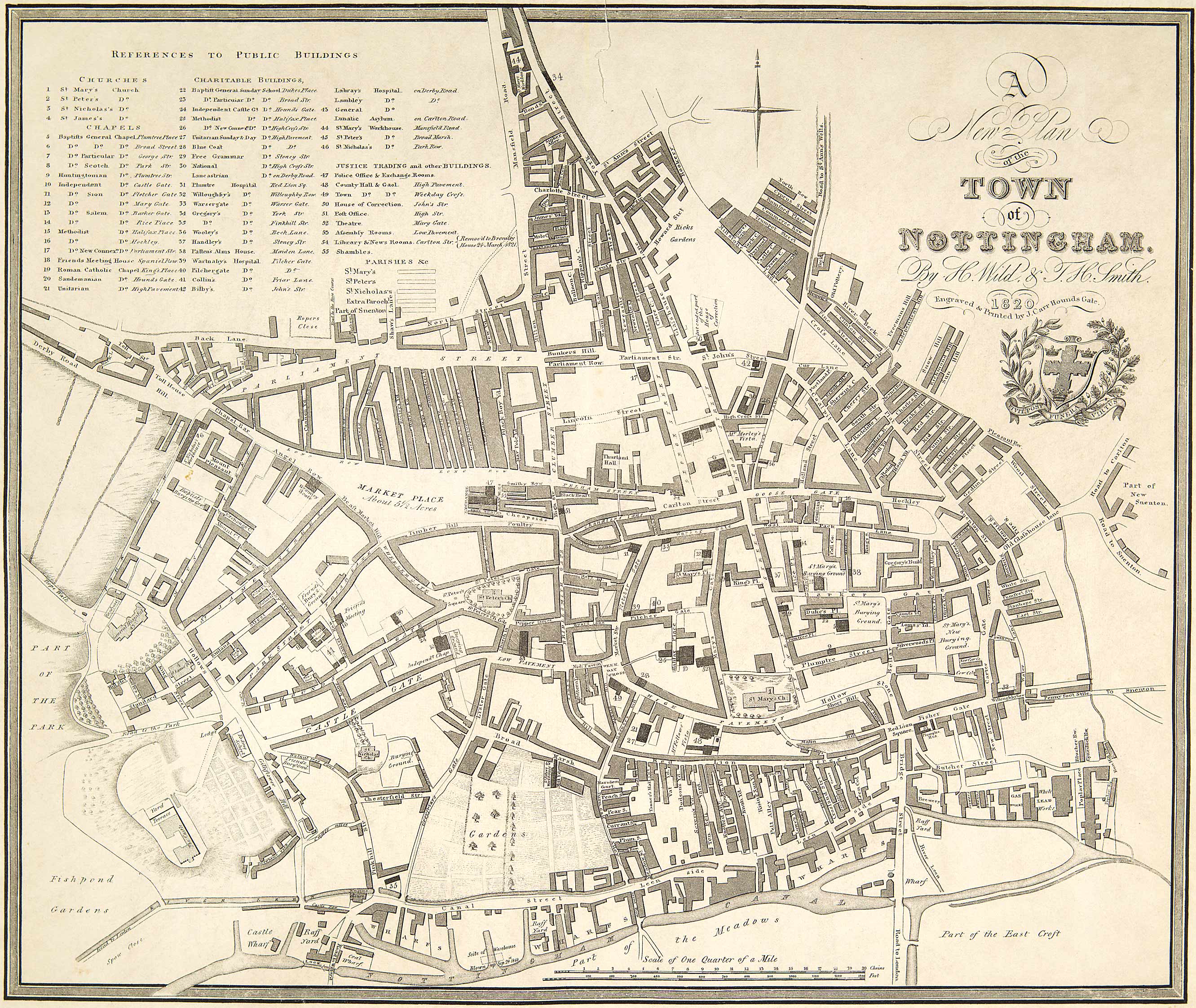
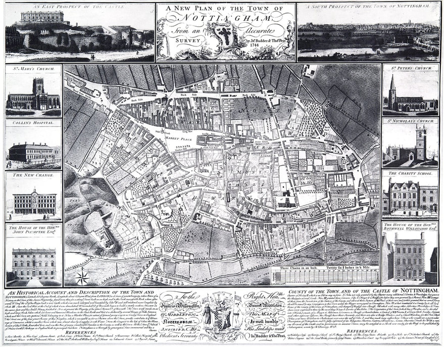
1820_nottingham_.jpg
File Size: 1115 kb
File Type: jpg
Download File

1861_nottingham_frdk_jackson.pdf
File Size: 4795 kb
File Type: pdf
Download File

1861_original_map.pdf
File Size: 9149 kb
File Type: pdf
Download File

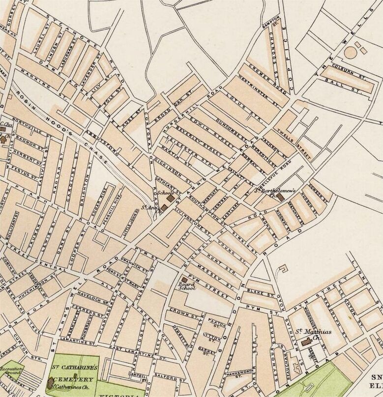
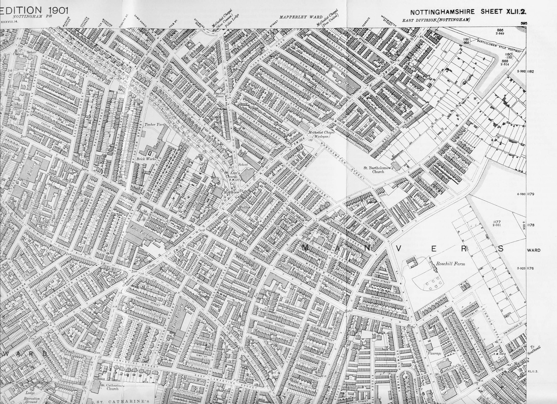
1901_central_nottm_ordnance_map.jpg
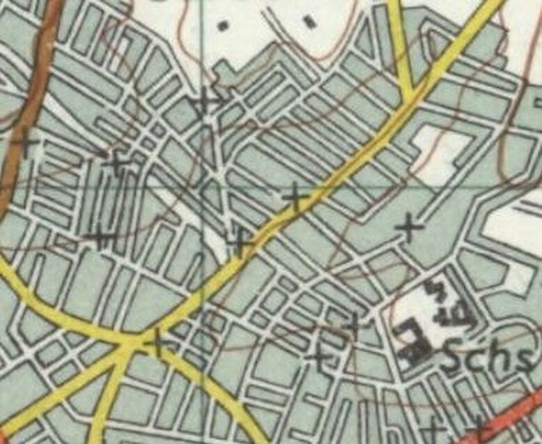
File Size: 5309 kb
File Type: jpg
Download File

1920_nottingam_.jpg
File Size: 5075 kb
File Type: jpg
Download File

allotments.jpg
File Size: 572 kb
File Type: jpg
Download File

Picture
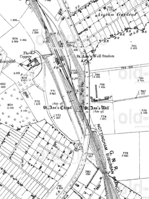
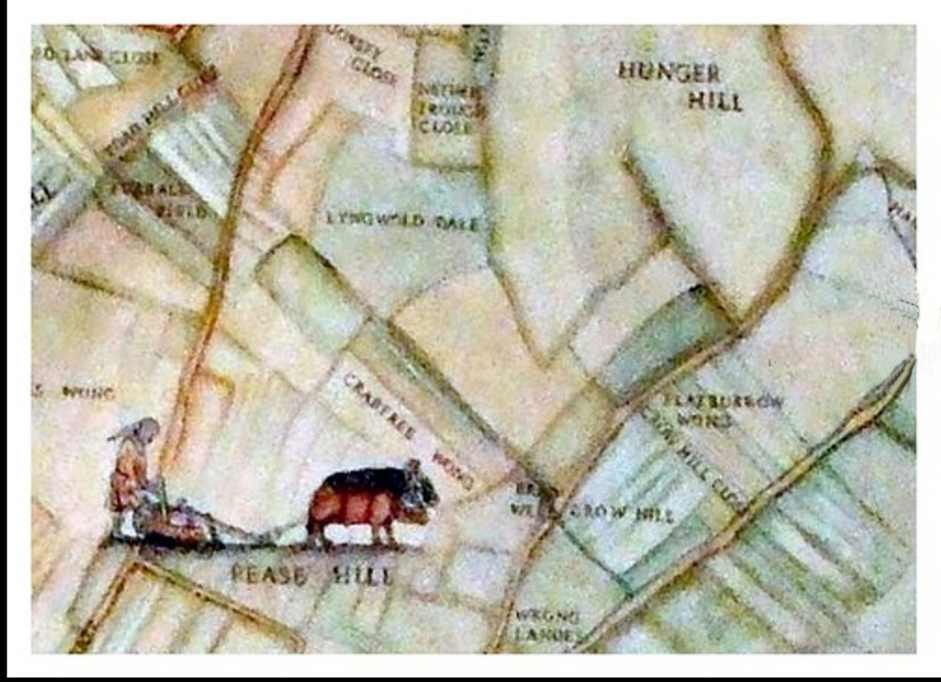
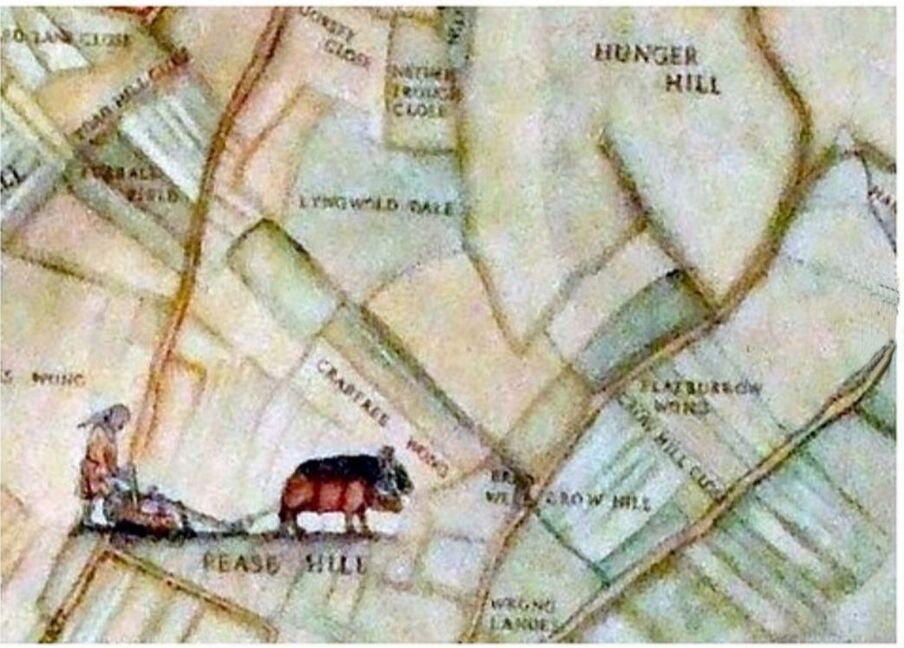
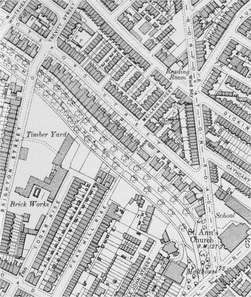
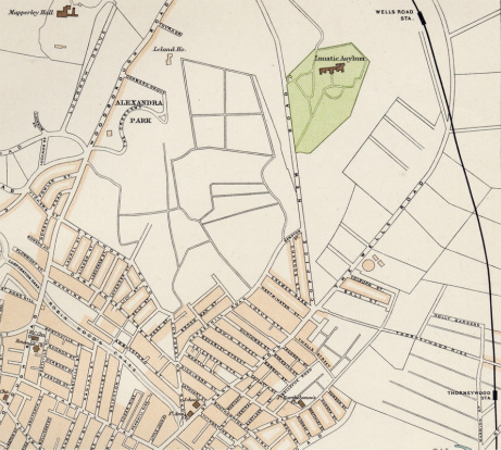
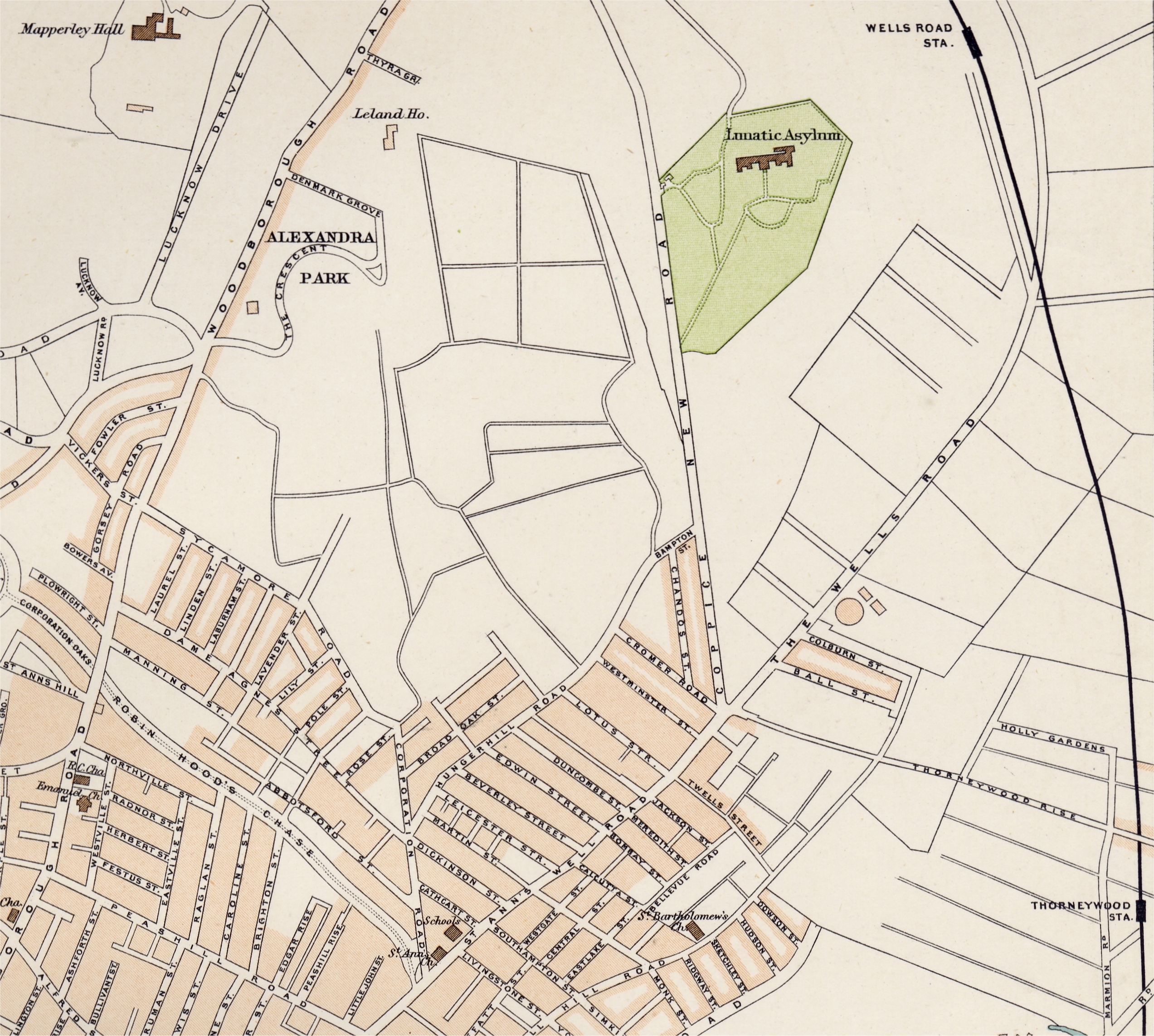
Map showing site of St Anns Well, St Anns Well Station and St Ann's Chapel (date unknown)
Picture
Picture
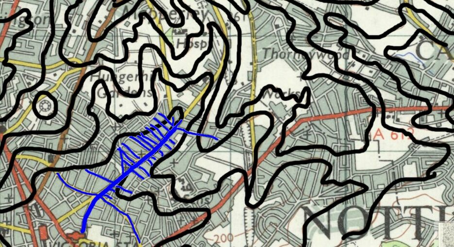
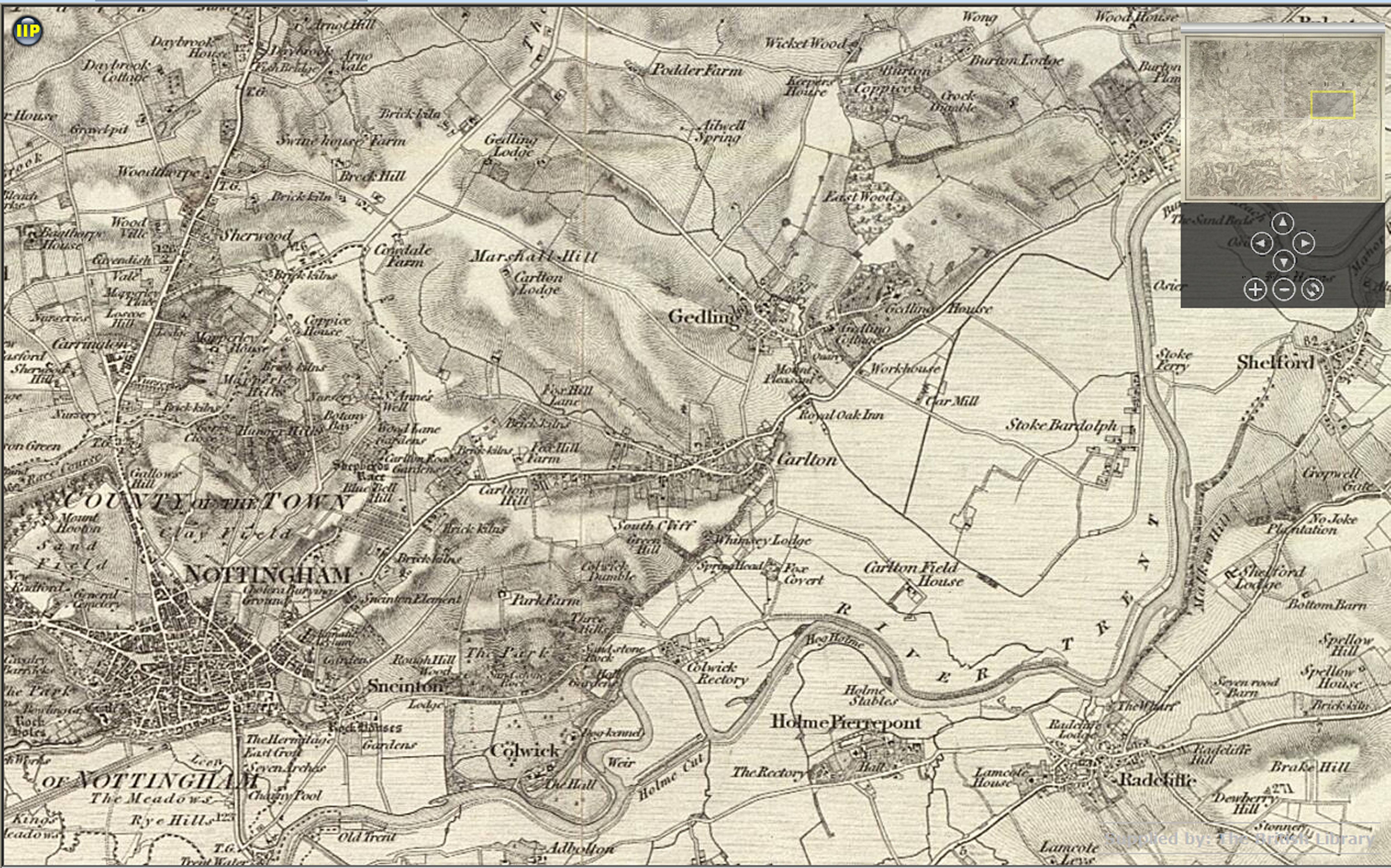
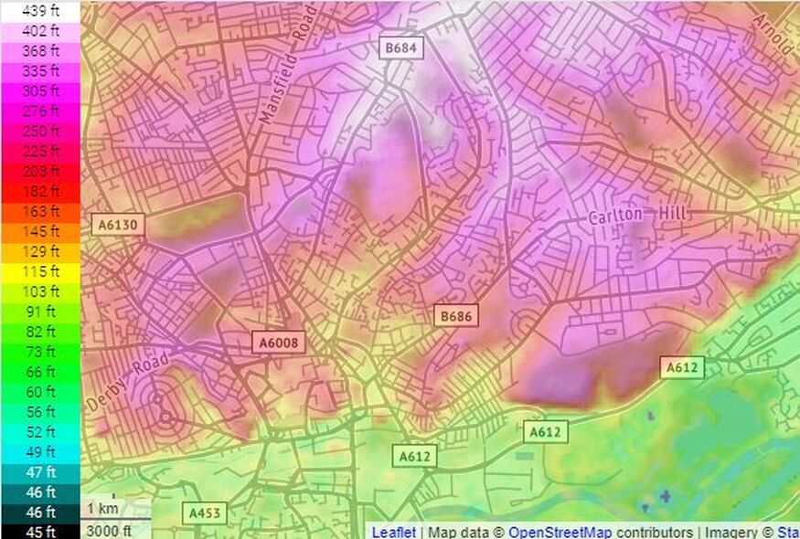
Map showing contours St Anns Well Road (blue) and immediate streets off
Picture
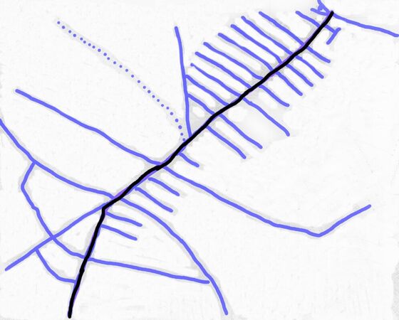
Diagram of the layout of St Anns Well Road and streets/roads directly off .
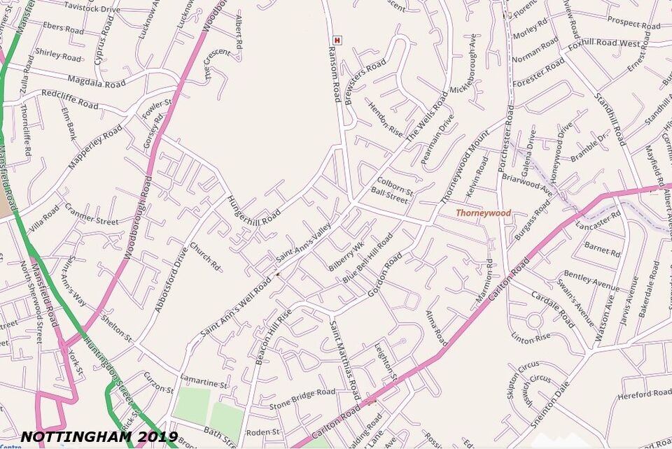
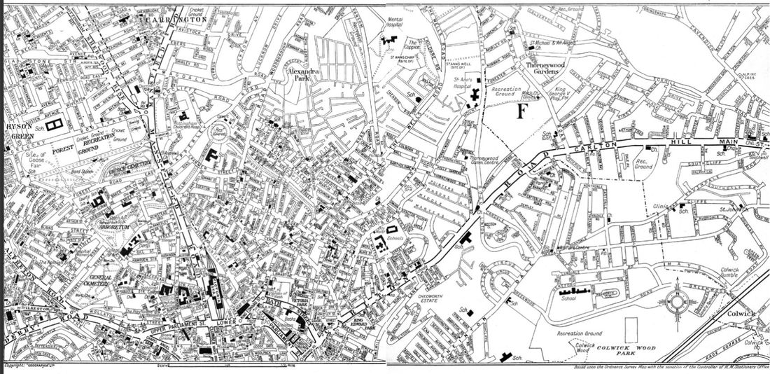
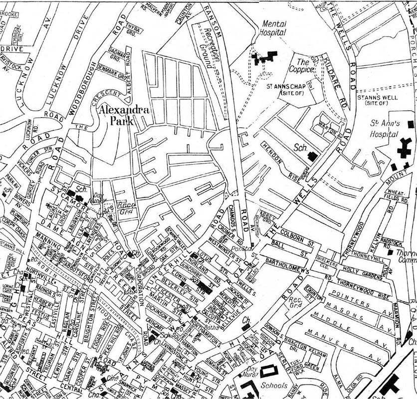
Picture
Picture
Nottingham 1960
Picture
modern topographic map
Picture
St Anns - A Brief History
THE VIRTUAL WALK - click here
Picture
Link to National Library of Scotland for the map below - to zoom in

Picture
Picture
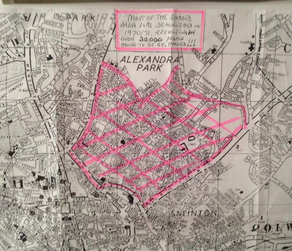
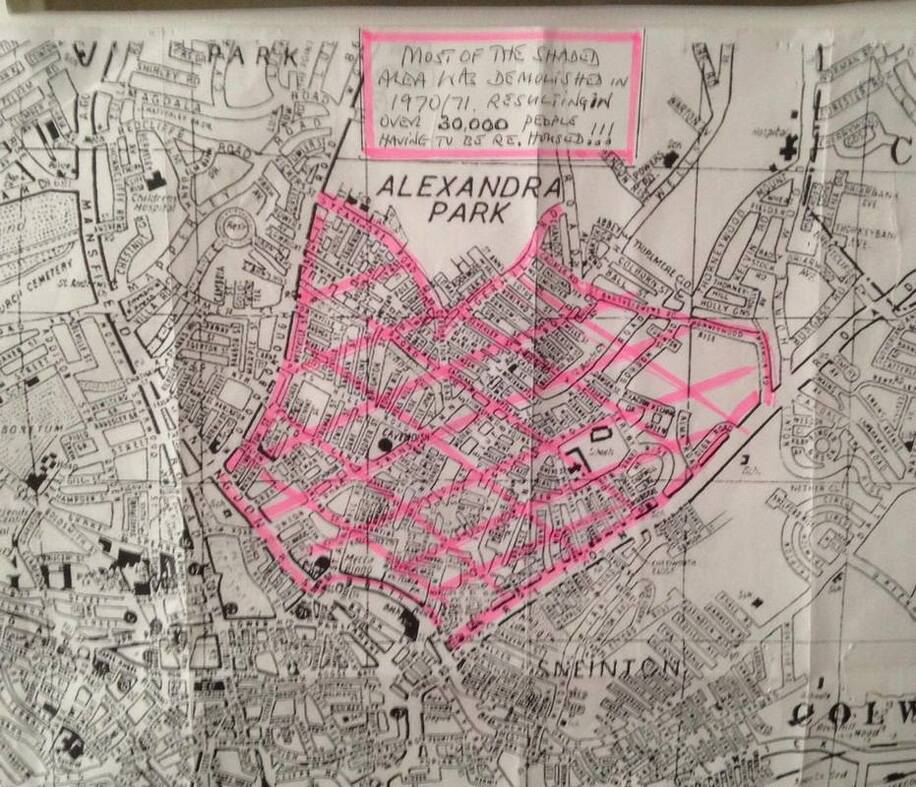
...it certainly focuses the mind when you actually see how many households, shop's etc that,were demolished during the redevelopment in the early 70's.......Tony
Picture
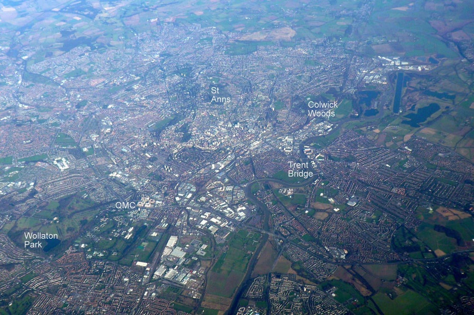
I thought it might be useful to see where St Anns fits into the picture of Nottingham from the air. I managed to take this photo a few years ago from an airliner on my way to Chicago. The weather was good and our route took us nicely just West of the city. I have added a few places to orientate your view. I have typed St Anns right over the Hungerhill Gardens, you can see the dark line of St Anns Well Rd and then Carlton Rd to the right of it. You can see how the original city was all crammed in and then the areas such as St Anns, Sneinton and Mapperley all spread out across the fields later. You can use google maps to tie in any places you are looking for on the photo. (Beq-Steve Clark)
INTERESTING LINK -
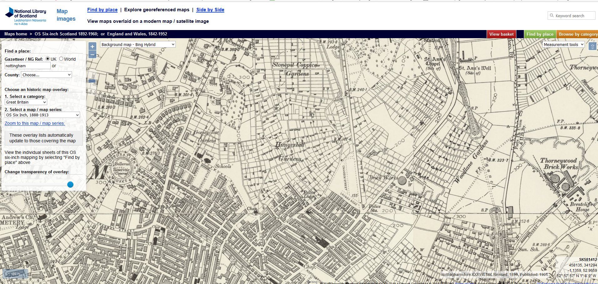
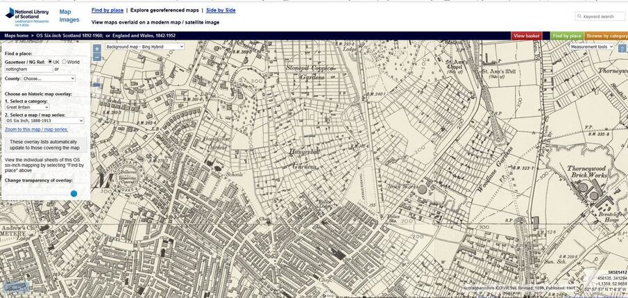
....overlap 19th century maps with modern maps or Google aerial photographs. It's a great opportunity to see where your ancestors lived in relation to modern maps 
http://maps.nls.uk/geo/explore/
Picture
 
MORE DOWNLOADABLE MAPS
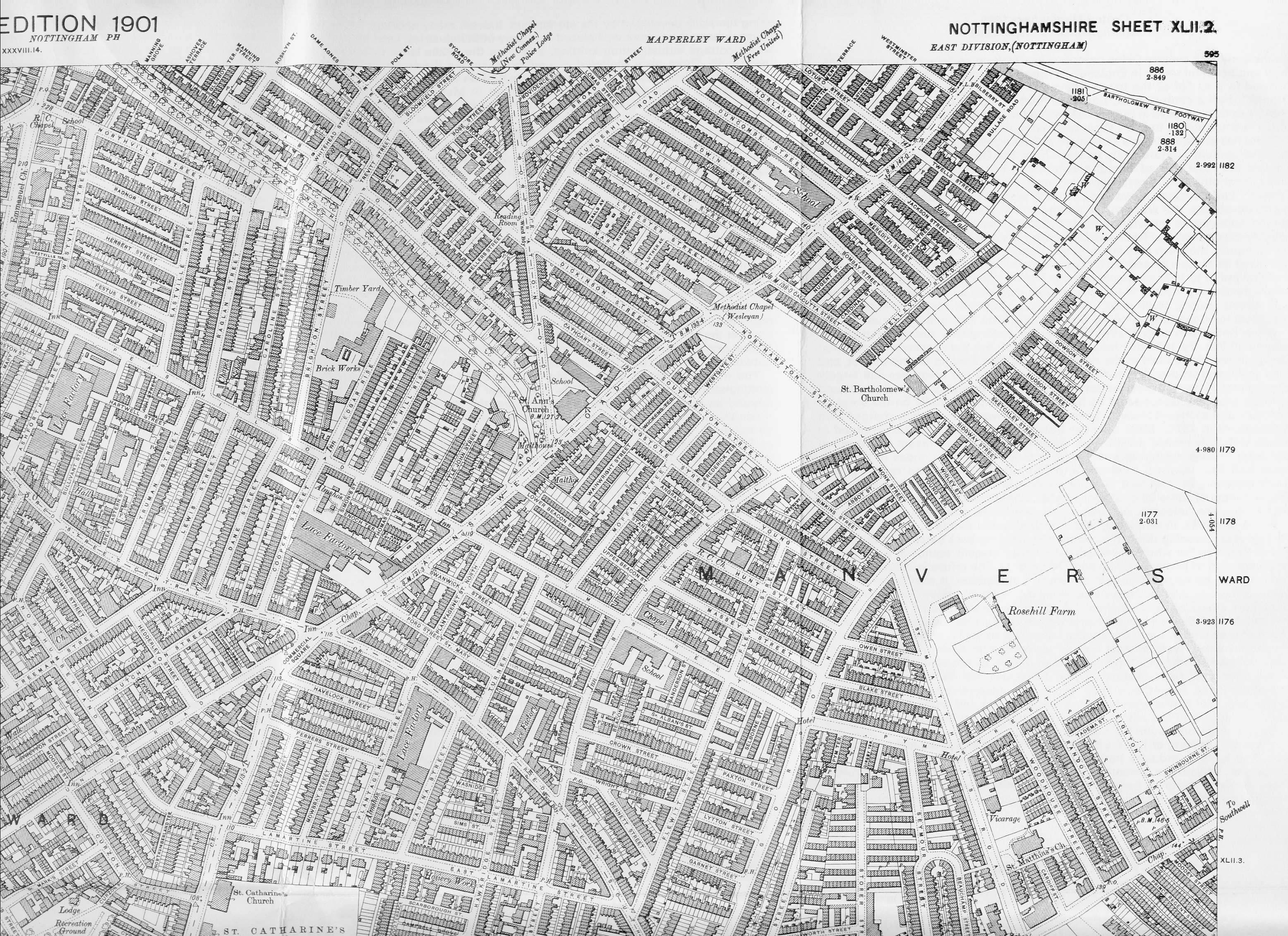
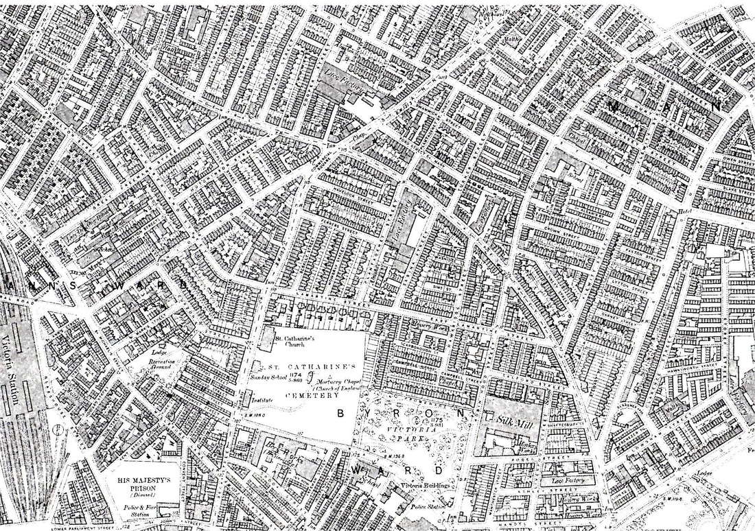
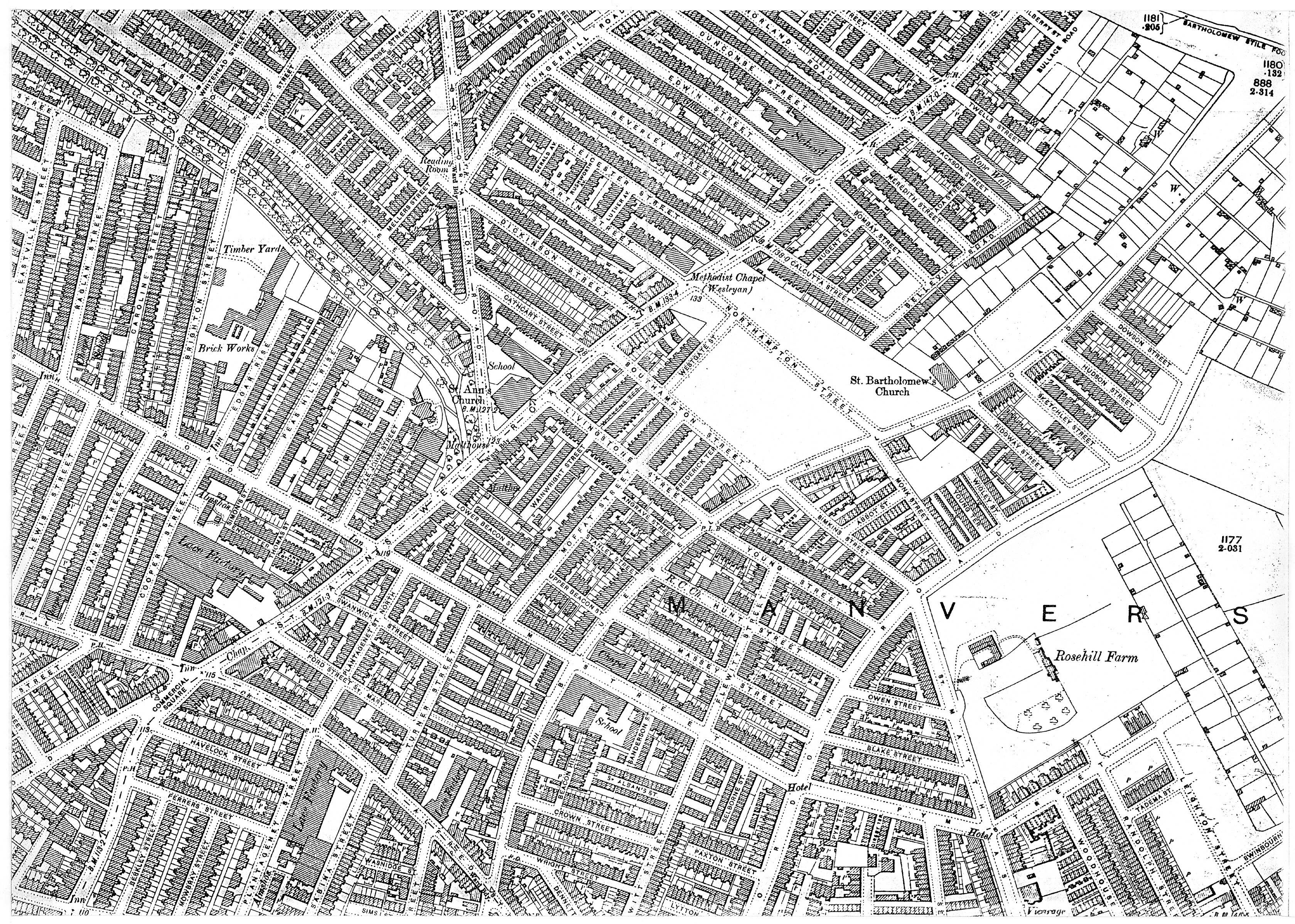
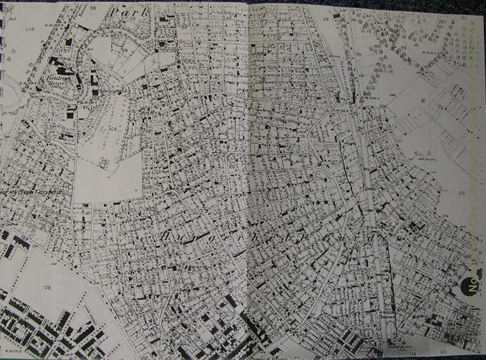
1901 (part)  St Ann's Well Rd  (entire length of road)
1901_st_anns_well_rd.jpg
File Size: 1711 kb
File Type: jpg
Download File

Picture
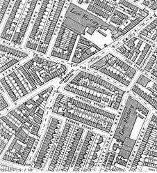
1899 (part map) St Ann's Well Rd to Pym St
1899_st_anns_well_rd_up_to_pym_st.jpg
File Size: 1170 kb
File Type: jpg
Download File

Picture
1885 (part map) Before Commercial Sq
before_commercial_sq_approx_1885.jpg
File Size: 394 kb
File Type: jpg
Download File

Picture
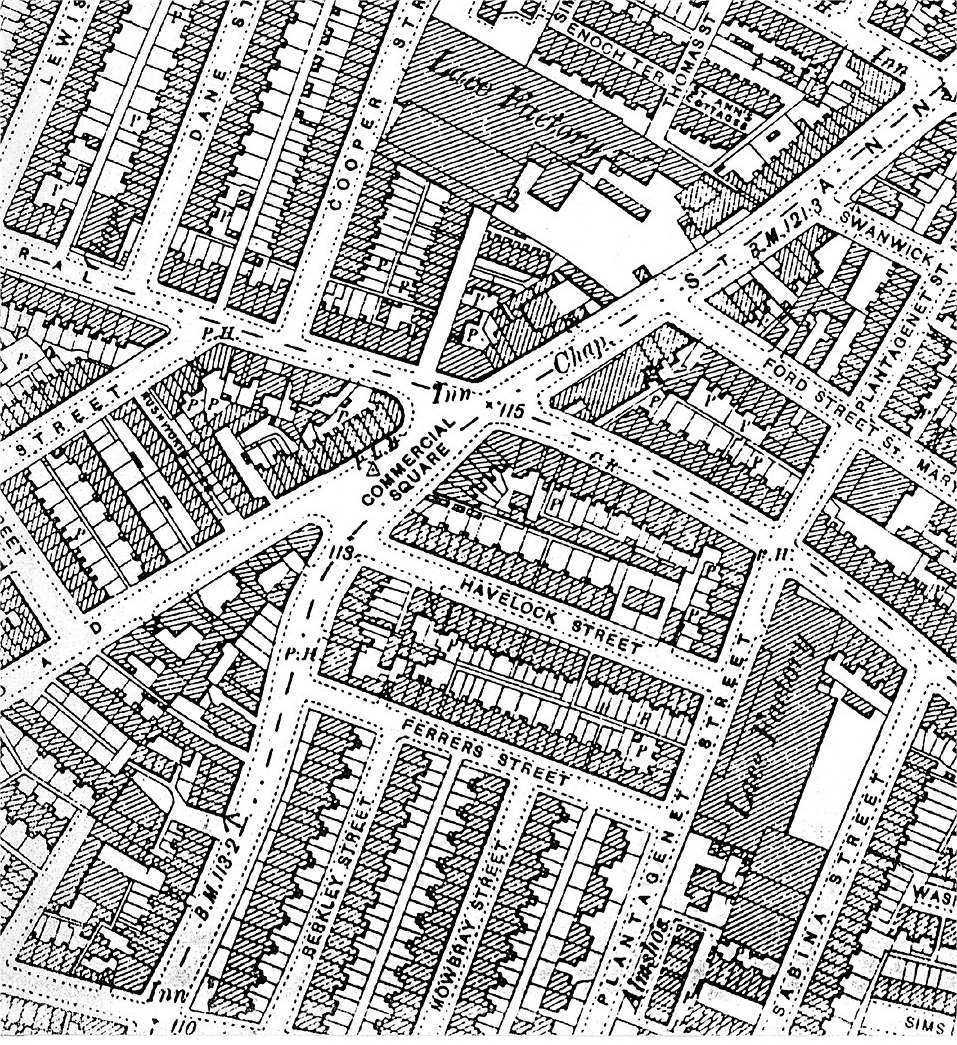
1885 (part map ) Commercial Sq to Northampton St
1885_commercial_sq_to_northampton_st.jpg
File Size: 2581 kb
File Type: jpg
Download File

Picture
(1901 part map) St Ann's Church and Robin Hood Chase 
1901_st_anns_and_the_chase.jpg
File Size: 141 kb
File Type: jpg
Download File

Picture
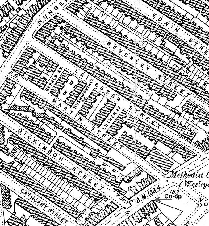
Co-op location and methodist church
co_op_location_and_methodist_church.jpg
File Size: 193 kb
File Type: jpg
Download File

Picture
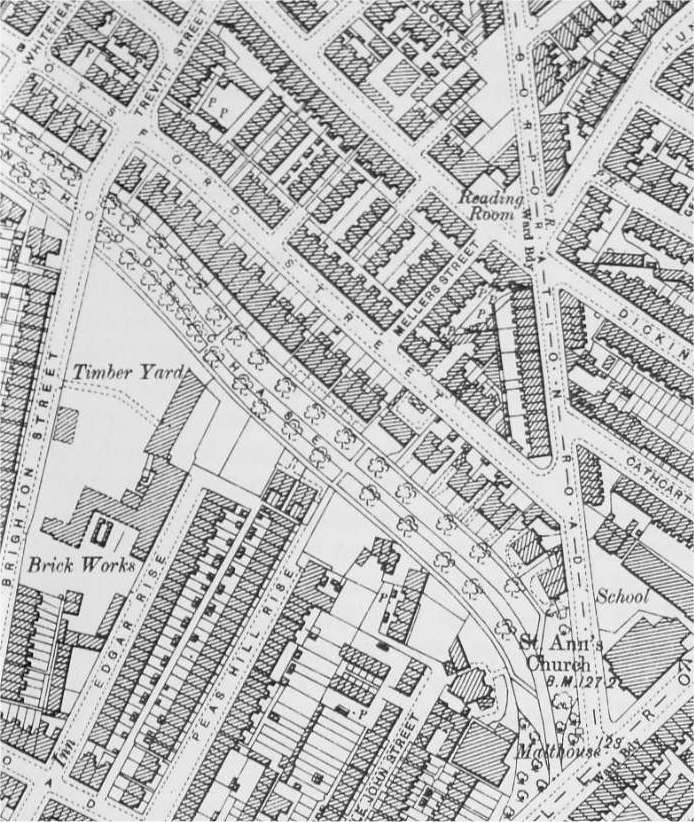
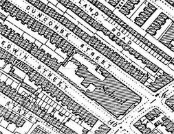
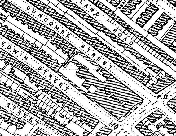
1885 (part map) Board School (Duncombe and Edwin St)


​1919 map
1885_board_school.jpg
File Size: 96 kb
File Type: jpg
Download File

1919.jpg
File Size: 918 kb
File Type: jpg
Download File

Picture
Picture
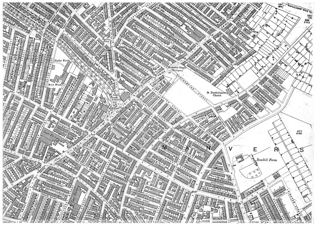
1920 Top end of St Anns Well Road - Wells Road, Ransom Rd, Donley Hill (St Bartholomews)
map_1920_hungerhill_rd.jpg
File Size: 3275 kb
File Type: jpg
Download File

Picture
1960 (part map) showing allotments
map_1960_portion_of_map.jpg
File Size: 324 kb
File Type: jpg
Download File

Picture
Hungerhill Allotments layout


no_date_allotments_nottm_council.jpg
File Size: 128 kb
File Type: jpg
Download File

Picture
Link  to facebook Photo Album 'MAPS' (CLICK HERE)
  • Home
    • Facebook group History
    • About & Guidleines
    • Contact
    • EVENTS >
      • 2025
      • 2024 Annual Gathering
      • 2023 Annual Gathering
      • 2022 Annual Gathering
      • 2021 Annual Gathering
      • 2018 Annual Gathering
      • 2019 Annual Gathering
      • 2017 Annual Gathering
      • 2016 Annual Gathering
      • 2015 Annual Gathering
      • 2014 Annual Gathering
      • 2013 Inaugural Gathering
      • 2017 Cinema visit "Some Like it Hot"
      • 2016 - Movie outing
    • Join the facebook group
  • Tony
  • INDEX
    • 1970s Nottingham Post
    • A VIRTUAL ART GALLERY - art by our members
    • Allotments - Hungerhill Gardens
    • Anecdotes Stories and Memories >
      • Talking 'bout - WASH DAYS - HOUSEWORK - KEEPING CLEAN ETC
      • Telling Tales
      • The Call of the Streets
      • The Weather
    • BLUE PLAQUES (Special Establishments)
    • BLUE PLAQUES (Unsung Heros)
    • Do you remember?
    • Boys Brigade & Girls Brigade
    • BB Tribute
    • Bonfire Night
    • Brownies Girl Guides Cubs Scouts etc
    • CHRISTMAS
    • Central Market
    • Cinema - Cavendish
    • Cinema - The Empress
    • Coppice Rec
    • Dance Halls in Nottingham
    • Dance HallL Palais de Danse
    • Downloadable Files
    • External Links-
    • 'Famous' >
      • Speedway - Fred Strecker
    • Fish and Chips
    • GAMES - snobs, hopscotch, buttercups, balls, skipping
    • GARDEN OF REST >
      • Harry Taylor
    • Hopewells
    • INTERVIEWS & STORIES >
      • Albert Spooner - The Place Where I Lived
      • Sistino Rao
      • Steve Bloomer
      • STORIES FROM ALAN DURY
    • Lace
    • 'MAPS'
    • Mr Salt - Board School Headmaster
    • Member Walks
    • 'Poetry' >
      • Poetry by Jean Taylor
      • Poetry by Geoff Freeman
      • Poem by Sid Wheeldon
      • Poetry by Chris Moore
      • Poetry by Bruce Lakin
    • Pownall
    • Press Clippings >
      • transcription1
    • Ray Gosling
    • Ruth I Johns (author Inner City Voices"
    • School Days The Happiest Days of your Life
    • Shops etc
    • St Ann's Well
    • Sneinton Market (Bath St)
    • Sound Bites
    • Trolley Buses
    • The Library
    • The Lost Generations by Paul Henson
    • What was "the demolition"
    • Wedding Day
    • Work
  • STREETS
    • STREETS directly off St Anns Well Rd
    • STREETS listed aphabetically
    • Abbey Grove (The Wells Rd to Richmond Ave)
    • Abbotsford St (off Corporation Road)
    • Abbott Street
    • Ada St (Meredith St to Jackson St)
    • Alfred St Central & North
    • Alfred St South
    • Alison Rise (off Alfred St Central)
    • Alpine Tce
    • Angrave St (off Moffat St)
    • Ash St (off Peas Hill Rd)
    • Ashforth St (off Alfred St Central)
    • Ashley St
    • Ashover Tce
    • Ball St (The Wells Rd to Blue Bell Hill Rd)
    • Bangor St
    • BATH STREET
    • Beacon St
    • Beaconsfield Tce
    • Beauchamp St
    • Beaumont Place (off Beaumont St)
    • Belle Vue Road (Northampton to Jackson St)
    • Berkeley St (off Lamartine St)
    • Beverley St >
      • Jill West nee Pettit
    • Bilberry St
    • Birkland Avenue (Peel St to Annesley Grove)
    • Blake St (Gordon Rd to Pym St)
    • Bloomfield St (off Dame Agnes St)
    • Bluebell Hill Road (off Alfred St South)
    • Bombay St >
      • Mick & Connie Newton
    • Bowers Ave (Woodborough Road to Park Ave)
    • Bracton Drive (Gordon Rd Estate)
    • Brighton Street (Peas Hill Rd to Robin Hood's Chase) >
      • Angie Miles nee Cundy
    • Broad Oak Street (Corporation Rd to St Ann's Valley)
    • Brook St
    • Bullace Road (off Bilberry St)
    • Bullivant St (off Alfred St Central)
    • Burgass Tce
    • Burton's Yard
    • Bycrofts Yard
    • Calcutta St
    • Campbell Grove (off Hawkridge St)
    • Cardiff St
    • Cardinal St and Cardinal Tce (off Calcutta St)
    • Carnarvon Street (Woodborough Rd to Marple St)
    • Caroline St (Peas Hill Rd to Abbotsford St)
    • Cathcart St >
      • Maureen Barker
    • Central St (opposite 29 Northampton St)
    • Chadburn St (off Dame Agnes St)
    • Chandos St (Cromer Rd to Hungerhill Rd)
    • Chaucer Tce (off Harlaxton St)
    • Clarence Street (off Carlton Rd)
    • Coalpit Lane
    • Colborn Street (The Wells Rd to Blue Bell Hill Rd)
    • Commercial Square
    • Comyn St (off Great Freeman St)
    • Conway St
    • Cooper Street (Alfred St Central to Peas Hill Rd)
    • Copestakes Yard
    • Corporation Rd
    • Courtnay Tce (off Westville St)
    • Cranmer St and Cranmer Grove
    • Cromer Road (Ransom Rd to Hungerhill Rd)
    • Cromwell Tce off Alfred St
    • Crown St (Bluebell Hill to Flewitt St)
    • Curzon St
    • Dame Agnes Street (Woodborough Rd to Corporation Rd) - inc Dame Agnes Tce
    • Dane Street (Alfred St Central to Peas Hill Rd)
    • Darby Tce (off Lotus St)
    • Daykene St
    • Dennett St (Flewitt St to Wright St)
    • Dickinson St
    • Dover Tce (off Lotus St)
    • Dowson St (Blue Bell Hill to Gordon Rd)
    • Duncombe St
    • Eastville St (Peas Hill Rd to Northville St)
    • Edgar Rise (off Peas Hill Rd)
    • Edwin St >
      • Tony Miller
    • Egerton St (St Ann's Hill to Bangor St)
    • Elm Grove (Off BlueBell Hill Rd)
    • Enoch Tce
    • Fairhome Tce off Storer St
    • Ferrers St
    • Festus St (Eastville St to Westville St)
    • Flewitt St (Alfred St South to Young St)
    • Ford St St Mary
    • Franchise Terrace (off Westminster St)
    • Frederick Tce
    • Freeman St
    • Fyne St
    • Gerald Ave (Off Martin St)
    • Garnett St (off Gordon Rd)
    • Girsby Tce (off Pym St)
    • Gladstone Street St Mary (Alfred St Central to Palmerstone St)
    • Glasshouse St (Lower Parliament St to Union Rd)
    • Glenroy Tce (Opposite Manning St)
    • Gordon Road (Lowdham St to Bartholomew Rd)
    • Great Eastern St & Tce (off Alfred St Central)
    • Great Freeman St (Huntingdon St to Alfred St Central)
    • Guys Terrace (off Blue Bell Hill Rd)
    • HANDEL ST
    • Harcourt Tce (Lamartine to Scarborough St)
    • Hardy Tce (off Simkins St)
    • Harlaxton St (Woodborough Rd to Heskey St)
    • Hartwell St (Truman St to Peas Hill Rd)
    • Harvey Tce (opposite Monk St)
    • Havelock St
    • Hawkridge St (Campbell Grove to Alfred St South)
    • Hawksworth St (Storer St to Clarence St)
    • Heath's Tce (off Lotus St)
    • Hedderley Street (Union Rd to Great Freeman St)
    • Hendon Rise (off The Wells Rd)
    • Herbert Street (Eastville St to Westville St)
    • Heskey Street (Huntingdon St to Alfred St North)
    • Hogarth St
    • Holly Gardens (Thorneywood Mount to Marmion Rd)
    • Howard St (Glasshouse St to Huntingdon St)
    • Hudson Street (Blue Bell Hill Rd to Gordon Rd)
    • Hungerhill Road (Corporation Rd to Ransom Rd)
    • Hunt Street (Blue Bell Hill to Gordon Rd)
    • Huntingdon St (Alfred St North to Mansfield Rd to Lower Parliament St)
    • Hutchinson St (Northumberland St to Alfred St Central)
    • Independent Hill
    • Jackson St
    • Jackson Tce (Off Simpkin St)
    • Kebir Tce
    • Kelham Green
    • Kemps Cottages (Lowdham St to Carlton Rd)
    • Kilbourn St
    • Kildare Rd
    • Laburnum St (Dame Agnes St to Sycamore Rd)
    • Lamartine St >
      • letter lamatine st
    • Laurel St (Dame Agnes St to Sycamore Rd) and Laurel Tce >
      • BRIAN ARAM
    • Lavender St (off Dame Agnes St)
    • Leeson St (off Great Freeman St)
    • Leicester St
    • Leighton St
    • Lewis St (Alfred St Central to Peas Hill Rd)
    • Lilac St (Dame Agnes St to Sycamore Rd)
    • Lily St (Dame Agnes St to Sycamore Rd)
    • Lime Tce
    • Linden St (Dame Agnes St to Sycamore Rd)
    • Little John St (off Peas Hill Rd) & Little John Tce
    • Livingstone St
    • Lomas Street off Hungerhill Rd
    • Lorne Grove
    • Lotus St
    • Loverseed Tce and Loverseed Vale
    • Lowdham St
    • Ludlow Tce (Dame Agnes St to Corporation Rd)
    • Lupin St
    • Luther Ave (Martin St to Leicester St)
    • Lytton St (off Gordon Rd)
    • Manchester St
    • Manning Grove (Manning St to Robin Hood Chase)
    • Manning St (Woodborough Rd to Trevitt St) >
      • Richard Pykett
    • Manning Tce (off Abbotsford St)
    • Mansfield Road
    • Marple Street (Alfred St North to Cranmer St)
    • Martin St
    • Massey St (Blue Bell Hill Rd to Gordon Rd)
    • Mellers St (Dame Agnes St to Abbotsford St)
    • Meredith St
    • Moffat St (Southampton St to Pym St)
    • Monk Street (Blue Bell Hill Rd to Gordon Rd)
    • Mornington St (Wellington St to Woodborough Rd)
    • Mowbray St (Lamartine St to Ferrers St)
    • National Tce (off Westminster St)
    • Nile St
    • Norfolk Tce
    • Norland Rd >
      • Barry Taylor - Norland Rd
    • Northampton St
    • Northumberland St >
      • Barry Taylor - Northumberland St
    • NORTHUMBERLAND TCE
    • Northville St and Northville Tce (Raglan St to Woodborough Rd)
    • Nugent St (Calcutta to Bombay St)
    • Oldham St
    • Owen St and Owen Place (Gordon Rd to St Matthias' St)
    • Palmerston St (Woodborough Rd to Gladstone St St Mary)
    • Parrott Place
    • Paxton St (Gordon Rd to Flewitt St)
    • Peas Hill Rise (Peas Hill Rd to Robin Hood Chase)
    • Peas Hill Rd
    • Penrhyn Tce
    • Plantagenet St (Lamartine St to Alfred St & thence to Pym St)
    • Pole Street (off Dame Agnes St)
    • Promenade (Robin Hood St to Robin Hood Tce)
    • Providence St (Off Corporation Rd)
    • Pym St
    • Pym Tce
    • Radnor St (Eastville St to Westville St)
    • RAGLAN STREET (Peas Hill Rd to Northville St) >
      • Dan Cox
    • Rancliffe Tce (off Pym St)
    • Randolph St (Carlton Rd to Pym St)
    • Ransom Rd/Coppice Rd >
      • Maureen Francis
    • Reform Tce (off Westminster St)
    • Richmond Ave (The Wells Rd to Abbey Grove) >
      • Michael Ward & Leslie Oliver
    • Rick St
    • Ridding Tce off Wellington St
    • Ridgway St (Blue BellHill Rd to Gordon Rd)
    • Ridgway Tce (off Ridgway St)
    • Rigley Terrace
    • Ritson Tce (off Scarborough St)
    • Robin Hood Chase
    • Robin Hood Street
    • Robin Hood Terrace
    • Rookwood Rd (Lomas St to St Ann's Valley)
    • Rose St (Dame Agnes St to Corporation Rd)
    • Rushton Tce
    • Rushworth Tce (off Hutchinson St)
    • St Alban's St (off Flewitt St)
    • St Ann's Cottages (off Thomas St)
    • St Ann's Hill and St Ann's Hill Rd
    • St Ann's St
    • St Ann's Valley
    • St Bartholomews - DONKEY HILL
    • St Leger Tce (off Westminster St)
    • St Mark's St (Huntingdon St to Curzon St)
    • St Matthias Road
    • Sabina St (Alfred St South to Lamartine St)
    • Salford St (Robin Hood St to Alfred St South)
    • Saxon Place
    • Scarborough St (off Hawkridge )
    • Selbourne Street (off Pym St)
    • Serlby Rise
    • Seymour St (Carlton Rd to Pym St) also Seymour Tce
    • Shaftsbury St
    • Shelton St (Great Freeman St to Woodborough Rd)
    • Sherwin Street
    • Simkins St (Blue Bell Hill Rd to Gordon Rd)
    • Simons Tce (off Westminster St)
    • Sims St (off Hawkridge St)
    • Sketchley St (Blue Bell Hill Rd to Gordon Rd)
    • Southampton St
    • Sprotborough Tce (Salford St to Lamartine St)
    • Stanley Street (Blue Bell Hil Rd to Moffat St)
    • Stewart Place (off Alfred St) >
      • Paul Jackson
    • Stokes Place
    • Stone Tce
    • Storer St & Storer, Arthur, Lawrence & Lime Tces
    • Stretton St (Moore St, Union Rd)
    • Swanwick St
    • Sycamore Rd (Woodborough Rd to Corporation Rd)
    • The Wells Road >
      • Wells Road Walk
    • Trevitt St (Dame Agnes St to Robin Hood Chase)
    • Thornywood Rise
    • Truman St (Alfred St Central to Peas Hill Rd)
    • Turner St (Alfred St South to Pym St) >
      • Barry Taylor - Turner St
      • Anne Binns
    • Twells St
    • UNION PLACE GLASSHOUSE ST
    • Union Road and Union Cottages >
      • David Foster
      • Union Rd Virtual Walk
    • Vicarage Street
    • Vickers St
    • Wainwright Passage
    • Wainwright St (off Livingstone St)
    • Warren Court (area behind Vic Centre)
    • Warton Ave
    • Wasnidge St (off Hawkridge St)
    • Watkin St (Huntingdon St to Shelton St)
    • Welbeck St (Huntingdon St to Alfred St)
    • Wellington St (Alfred St Central to Huntingdon St)
    • Westgate St (Off Southampton St)
    • Westminster St
    • Westminster Tce (off Westminster St)
    • Westville St - Westville Tce (Peas Hill Rd to Northville St) >
      • Mick Doyle
    • Whitehead St (Dame Agnes St to Robin Hood Chase)
    • Wickens Tce
    • Woodborough Road (Mansfield Rd to City Boundary)
    • Woodhouse St (Carlton to Pym st)
    • Wright St (Blue Bell Hill Rd to Flewitt St)
    • Young St (Blue Bell Hill Rd to Gordon Rd)
    • Young's Tce (off Gordon Rd)
  • ST ANNS WELL ROAD
    • Where on the map did we live?
    • Where is St Anns Well Rd?
    • Links to streets directly off St Ann's Well Road
    • St Anns - a brief history
    • St Anns Well Rd 1911 - 1956 compare directories
  • 'VIRTUAL WALK'
    • Virtual Walk chat
  • CHURCHES
  • SCHOOLS
    • THE SCHOOL LIST - links
    • St Andrews - Alfred St School
    • Bath St
    • Bluebell Hill School
    • Board School
    • St Anns Well Road Board School Archives
    • Elliott Durham
    • Hogarth
    • Hollygirt
    • Huntingdon
    • Manvers
    • Manvers Pierrepont Bi-Lateral
    • Morley Junior School
    • Morley Secondary Modern School
    • Pierrepont Secondary Modern School for Girls
    • Shelton St Infants & Junior School
    • St Anns Church School
    • St Augustines
    • St Bernadettes School
    • St Edwards School
    • St Marks
    • Sycamore School
    • The Elms
    • Other Schools
    • Walter Halls
  • PUBS
    • PUBS
    • Pubs -by location - by pub name
    • Pubs of Nottingham 1891 census
    • Gather round the piano
  • WW1
    • THE GREAT WAR (WW1) Centennial Project
    • Research process
    • WW1 St Anns Church Memorial Names
    • St Ann's Church Men's Institute Memorial Plaque
    • WW1 Member Contributions
    • WW1 6TH Co BB Honour Roll
    • WW1 Memorial Dakeyne Street Lads' Club (2nd Nottingham Company Boys' Brigade)
    • WW1 Memorial St Bartholomews
    • WW1 Woodborough Rd Baptist
    • WW1 WOMEN
    • WW1 AUSTRALIAN CONNECTION >
      • HORACE NEWSTEAD
    • WW1 St Anns Well Rd 19 fallen
    • WW1 Other fallen from the area
    • WW1 Other Streets
    • WW1 Captain C G Vickers V.C.
    • WW1 'Burnt Records'
  • WW2
    • WW2 "They Served"
    • WW2 Commonwealth War Graves Commission
    • WW2 "The Home Front"
    • WW2 Nottingham press
    • WW2 BLOOMER FAMILY
    • WW2 The Night They Bombed Nottingham WW2
    • WW2 Member contributions
  • PHOTO COLLECTIONS
    • Dave Coleman Collection
    • Leon Pavich Collection
    • Peter Garner Collection
    • Peter Richardson END OF AN ERA -
    • PHOTOS an index
    • Dress Code
    • OUR BACKYARDS and FRONT DOOR STEPS
    • Treasured photos
    • Then and Now
    • INDIVIDUALS - THE FAMILIES - PEOPLE WE KNEW
    • Facebook Albums