CONCERNING "ST ANNS WELL"
St Anns Well
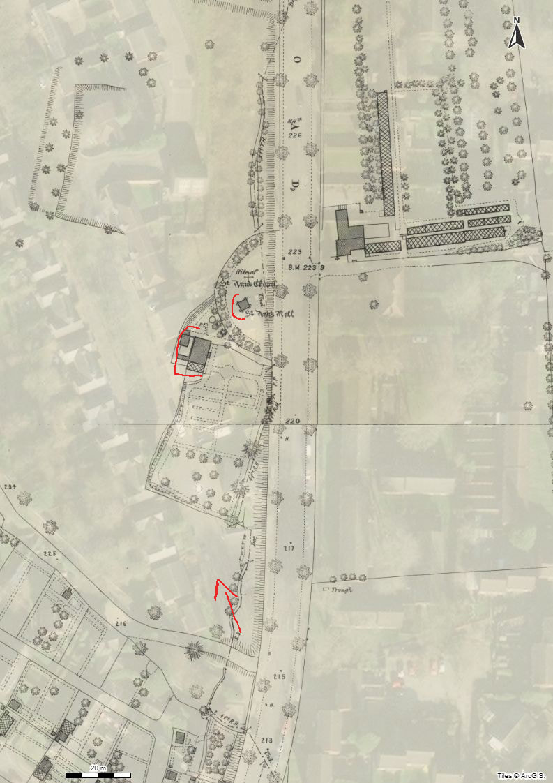
Source of above image: Geo Referenced Maps
External You tube link:
St Anns Well
Compiled by: Mavis Baker on Wednesday, March 7, 2012 at 10:29pm
Note on sources:
Various works have been consulted while compiling this article. To list them all would take up too much space so to avoid this I will simply cite the most important. Nottingham Borough Records, various volumes. Deering, C. Nottinghania Vetus et Nova. Ayscough & Willington, Nottingham, 1751. Morrell, R.W. St Ann's Well and Other Medicinal and Holy Wells of Nottingham. APRA/NUFOIS, 1987. Stapleton. Some Account of the Religious Institutions of Old Nottingham. Forman, 1899.
------------------------------------------------------------------------------------------------------------------------------------------------------------------------------------------
To the north of Nottingham in what was once Sherwood Forest is the site of the town's best known holy well, an ice-cold spring, the water of which had for centuries a reputation for being able to cure rheumatic afflictions and other ailments. Known now as St Ann's Well, this was not its earliest name but one given it by some monks who had seized the site and erected a chapel there which they dedicated to St Ann, renaming the spring in the process. Prior to this it had been called Robin Hood's Well. The change of name did not meet with local approval for people continued well into the 18th century to refer to the spring as Robin Hood's Well.
Circumstantial evidence derived from linguistic studies suggests the spring to have been a healing well in pre-Christian times. It enters history known as the Brodewell; a few years later it had become The Owswell. In Anglo-Saxon Brod (e) can mean 'coming together' or 'to shoot' or 'spout', thus the word could be used as a descriptive term for water emerging with some force from the rock at the side of the valley where the spring is located. The word Oss, or Os may well be a localised vulgarisation of the Anglo-Saxon Eostre, a fertility goddess whose festival was to be absorbed into the Christian cult to become Easter. At what date the spring became associated with Robin Hood is not known, but one might speculate that it was sometime in the thirteenth century when ballads about the outlaw had become popular.
The christianisation of Robin Hood's Well took place sometime early in the fourteenth century, while the unpopularity of the act is suggested by official local references to 'Robin Hood's Well alias St Ann's Well'. Some Nottingham antiquarians in the nineteenth century attempted to establish that there was a hermitage near the well. However, they produced no documentary or archaeological evidence in support of their contention. As hermits sought to keep away from the public it appears the notion that a hermitage should be located next to a major route from Nottingham to the north at a place which itself is highly improbable. Some time in the late fourteenth or early fifteenth centuries the authorities at St Mary's church Nottingham are said to have seized 'the great spring of the township' and built a chapel dedicated 'to the mother of the patroness of the church,' St Ann. This personage was mythical, as even the Roman Catholic authority on saints, Donald Attwater, admits. There is no trace either of a chapel dedicated to St Ann or 'a great spring' in medieval Nottingham, though there was a side altar dedicated to her in St Mary's itself, as might be expected. Consequently we must look elsewhere for both and the only place which fits in with the scenario is Robin Hood's Well a mile outside Nottingham but in an area in which the town authorities appear to have held properties.
St Mary's is the oldest Christian church in Nottingham, having been built in the settlement which was to develop into Nottingham. Bede has preserved a letter from the Pope to Melitus which encouraged missionaries to take over and desecrate pagan holy places. St Mary's was controlled by the Cluniacs of Lenton Priory, who had received its 'temporalities' as part of their endowment from the Norman overlord of Nottingham, William Peveril, who had invited them to settle near his town and castle sometime between 1109 and 1114. Abundant records testify to the Priory's greed and in respect to St Mary's they sought to extract the maximum revenue for minimal duties. By 1290 this situation had become such a scandal that the Archbishop of York was forced to install a resident vicar (perpetuus vicarius), to take charge of the church, though ultimate control of the revenues remained with the monks. It was in keeping with the character of such a monastic house to have viewed a popular but secular holy well as a potential source of additional income, hence their take-over. Sometime early in the fifteenth century, Bishop Edward Trollope gives the date as 1409 [1] the monks of Lenton had a chapel built adjacent to the spring, dedicating both it and the spring to St Ann.
The monks did not long enjoy the fruits of their ill-gotten gain, for within a few years of the construction of the chapel Lenton Priory was dissolved and its abbot hanged for taking part in the so-called Pilgrimage of Grace. The spring site reverted to the ownership of the Nottingham town authorities who abandoned the chapel while starting to develop the site both as the home for an official in charge of the town's woodlands but also to cater for visitors to the well, of which there were a great many. Eventually the site was to become a sort of pleasure ground cum spa and remained so until the first quarter of the nineteenth century.
On high ground to the south-east of the healing spring was to be found a turf maze called the Shepherds' Race, or Robin Hood's Race. At what date the maze was created is not known, though there is no reference to it in local records prior to the late seventeenth century. Local antiquarians have speculated at some length as to whether there was a connection between it and the healing well, but no one has yet come up with anything positive, except for one Earth mysteries 'authority' who managed to place the maze next to the well, having, it would seem, mistaken a small-sized nineteenth century replica of it dug near the well some years after the original maze had been ploughed on February 17, 1797 to make way for a field of potatoes. A second replica was created at a tea garden not far from the original maze site. Some antiquarians thought that monks serving St Ann's chapel had dug the maze 'to give themselves a breathing for want of other exercise', an idea Dr Trollope described as 'ludicrous' [2].
According to seventeenth century records the Mayor of Nottingham along with the town aldermen and local officials, all attired in their official robes of office and accompanied by their wives and the town musicians, processed from Nottingham annually every Black (Easter) Sunday to the spring. This tradition had commenced according to one local historian writing in the eighteenth century, 'time beyond memory'. However, at whatever date this custom originated (perhaps it was a secularised Rogationtide procession), it ceased at the outbreak of the Civil War and was never resumed, despite an attempt to revive it following the Restoration.
Despite its long popularity as a healing shrine only one print has been published actually showing it. This appears on a plate illustrating several Robin Hood relics published in Throsby's expanded edition of Robert Thoroton's History of Nottinghamshire (1797). The small engraving depicts the water of the spring to have been fed into a rectangular stone lined bath covered by an arched roof, perhaps of brink. Steps lead from a platform down into the water, which Throsby describes as being so cold that it would kill a toad. Several later writers who tried the water confirm it to have been exceptionally cold. No scale is given for the illustration.
In the late eighteenth and early nineteenth centuries the house at the well site became the centre of activities for what appears on the surface to have been a strange group of Robin Hood devotees known as the Brotherhood of the Chair. The 'rites' of this group involved the use of several relics said to be associated with Robin Hood which were preserved at the house. Visitors would be seated in Robin Hood's Chair then capped with his iron cap. Secretive features of the rites were hinted at but, if the historian, John Blackner, is to be believed, these consisted of nothing more than the consumption of 'large quantities of Woodward's nut-brown ale.'
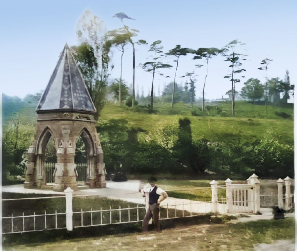
The development of the area in which the spring was located which commenced in the nineteenth century as Nottingham expanded, led eventually to a decline in the popularity of the spring site and in November 1855 the town authorities (Nottingham did not become a city until 1897) decided to redevelop the site. Such was the continuing affection for the ancient healing spring that in August of the following year the council decided to take steps to preserve the well itself by spending not more than £100 to enclose its site and cover it. A diminutive gothic-like spired structure was erected around which a small garden was laid out. Although the value of the spring's water was gained by bathing in it this was ignored, access to it only being provided for those who wanted to consume the water. This monument to past glories was to have a short life for in August 1887 it was demolished and the site sold to a railway company, who built an embankment over it. The council refused the railway company's offer of the well monument for erection elsewhere.
So an ancient healing well disappeared from public view, but not its existence, for excavations through the remains of the former railway embankment at the well site in 1987 established that the ancient spring still flows and may even be responsible for the flooding of some gardens from time to time. An attempt to interest Nottingham City Council in providing funds to establish a heritage centre at the site in which the ancient spring would have been the focal came to nought. The Council approved of the idea but not of having to find the money to carry it out. Perhaps, though, one day they will change their minds.
Compiled by: Mavis Baker on Wednesday, March 7, 2012 at 10:29pm
Note on sources:
Various works have been consulted while compiling this article. To list them all would take up too much space so to avoid this I will simply cite the most important. Nottingham Borough Records, various volumes. Deering, C. Nottinghania Vetus et Nova. Ayscough & Willington, Nottingham, 1751. Morrell, R.W. St Ann's Well and Other Medicinal and Holy Wells of Nottingham. APRA/NUFOIS, 1987. Stapleton. Some Account of the Religious Institutions of Old Nottingham. Forman, 1899.
------------------------------------------------------------------------------------------------------------------------------------------------------------------------------------------
To the north of Nottingham in what was once Sherwood Forest is the site of the town's best known holy well, an ice-cold spring, the water of which had for centuries a reputation for being able to cure rheumatic afflictions and other ailments. Known now as St Ann's Well, this was not its earliest name but one given it by some monks who had seized the site and erected a chapel there which they dedicated to St Ann, renaming the spring in the process. Prior to this it had been called Robin Hood's Well. The change of name did not meet with local approval for people continued well into the 18th century to refer to the spring as Robin Hood's Well.
Circumstantial evidence derived from linguistic studies suggests the spring to have been a healing well in pre-Christian times. It enters history known as the Brodewell; a few years later it had become The Owswell. In Anglo-Saxon Brod (e) can mean 'coming together' or 'to shoot' or 'spout', thus the word could be used as a descriptive term for water emerging with some force from the rock at the side of the valley where the spring is located. The word Oss, or Os may well be a localised vulgarisation of the Anglo-Saxon Eostre, a fertility goddess whose festival was to be absorbed into the Christian cult to become Easter. At what date the spring became associated with Robin Hood is not known, but one might speculate that it was sometime in the thirteenth century when ballads about the outlaw had become popular.
The christianisation of Robin Hood's Well took place sometime early in the fourteenth century, while the unpopularity of the act is suggested by official local references to 'Robin Hood's Well alias St Ann's Well'. Some Nottingham antiquarians in the nineteenth century attempted to establish that there was a hermitage near the well. However, they produced no documentary or archaeological evidence in support of their contention. As hermits sought to keep away from the public it appears the notion that a hermitage should be located next to a major route from Nottingham to the north at a place which itself is highly improbable. Some time in the late fourteenth or early fifteenth centuries the authorities at St Mary's church Nottingham are said to have seized 'the great spring of the township' and built a chapel dedicated 'to the mother of the patroness of the church,' St Ann. This personage was mythical, as even the Roman Catholic authority on saints, Donald Attwater, admits. There is no trace either of a chapel dedicated to St Ann or 'a great spring' in medieval Nottingham, though there was a side altar dedicated to her in St Mary's itself, as might be expected. Consequently we must look elsewhere for both and the only place which fits in with the scenario is Robin Hood's Well a mile outside Nottingham but in an area in which the town authorities appear to have held properties.
St Mary's is the oldest Christian church in Nottingham, having been built in the settlement which was to develop into Nottingham. Bede has preserved a letter from the Pope to Melitus which encouraged missionaries to take over and desecrate pagan holy places. St Mary's was controlled by the Cluniacs of Lenton Priory, who had received its 'temporalities' as part of their endowment from the Norman overlord of Nottingham, William Peveril, who had invited them to settle near his town and castle sometime between 1109 and 1114. Abundant records testify to the Priory's greed and in respect to St Mary's they sought to extract the maximum revenue for minimal duties. By 1290 this situation had become such a scandal that the Archbishop of York was forced to install a resident vicar (perpetuus vicarius), to take charge of the church, though ultimate control of the revenues remained with the monks. It was in keeping with the character of such a monastic house to have viewed a popular but secular holy well as a potential source of additional income, hence their take-over. Sometime early in the fifteenth century, Bishop Edward Trollope gives the date as 1409 [1] the monks of Lenton had a chapel built adjacent to the spring, dedicating both it and the spring to St Ann.
The monks did not long enjoy the fruits of their ill-gotten gain, for within a few years of the construction of the chapel Lenton Priory was dissolved and its abbot hanged for taking part in the so-called Pilgrimage of Grace. The spring site reverted to the ownership of the Nottingham town authorities who abandoned the chapel while starting to develop the site both as the home for an official in charge of the town's woodlands but also to cater for visitors to the well, of which there were a great many. Eventually the site was to become a sort of pleasure ground cum spa and remained so until the first quarter of the nineteenth century.
On high ground to the south-east of the healing spring was to be found a turf maze called the Shepherds' Race, or Robin Hood's Race. At what date the maze was created is not known, though there is no reference to it in local records prior to the late seventeenth century. Local antiquarians have speculated at some length as to whether there was a connection between it and the healing well, but no one has yet come up with anything positive, except for one Earth mysteries 'authority' who managed to place the maze next to the well, having, it would seem, mistaken a small-sized nineteenth century replica of it dug near the well some years after the original maze had been ploughed on February 17, 1797 to make way for a field of potatoes. A second replica was created at a tea garden not far from the original maze site. Some antiquarians thought that monks serving St Ann's chapel had dug the maze 'to give themselves a breathing for want of other exercise', an idea Dr Trollope described as 'ludicrous' [2].
According to seventeenth century records the Mayor of Nottingham along with the town aldermen and local officials, all attired in their official robes of office and accompanied by their wives and the town musicians, processed from Nottingham annually every Black (Easter) Sunday to the spring. This tradition had commenced according to one local historian writing in the eighteenth century, 'time beyond memory'. However, at whatever date this custom originated (perhaps it was a secularised Rogationtide procession), it ceased at the outbreak of the Civil War and was never resumed, despite an attempt to revive it following the Restoration.
Despite its long popularity as a healing shrine only one print has been published actually showing it. This appears on a plate illustrating several Robin Hood relics published in Throsby's expanded edition of Robert Thoroton's History of Nottinghamshire (1797). The small engraving depicts the water of the spring to have been fed into a rectangular stone lined bath covered by an arched roof, perhaps of brink. Steps lead from a platform down into the water, which Throsby describes as being so cold that it would kill a toad. Several later writers who tried the water confirm it to have been exceptionally cold. No scale is given for the illustration.
In the late eighteenth and early nineteenth centuries the house at the well site became the centre of activities for what appears on the surface to have been a strange group of Robin Hood devotees known as the Brotherhood of the Chair. The 'rites' of this group involved the use of several relics said to be associated with Robin Hood which were preserved at the house. Visitors would be seated in Robin Hood's Chair then capped with his iron cap. Secretive features of the rites were hinted at but, if the historian, John Blackner, is to be believed, these consisted of nothing more than the consumption of 'large quantities of Woodward's nut-brown ale.'
The development of the area in which the spring was located which commenced in the nineteenth century as Nottingham expanded, led eventually to a decline in the popularity of the spring site and in November 1855 the town authorities (Nottingham did not become a city until 1897) decided to redevelop the site. Such was the continuing affection for the ancient healing spring that in August of the following year the council decided to take steps to preserve the well itself by spending not more than £100 to enclose its site and cover it. A diminutive gothic-like spired structure was erected around which a small garden was laid out. Although the value of the spring's water was gained by bathing in it this was ignored, access to it only being provided for those who wanted to consume the water. This monument to past glories was to have a short life for in August 1887 it was demolished and the site sold to a railway company, who built an embankment over it. The council refused the railway company's offer of the well monument for erection elsewhere.
So an ancient healing well disappeared from public view, but not its existence, for excavations through the remains of the former railway embankment at the well site in 1987 established that the ancient spring still flows and may even be responsible for the flooding of some gardens from time to time. An attempt to interest Nottingham City Council in providing funds to establish a heritage centre at the site in which the ancient spring would have been the focal came to nought. The Council approved of the idea but not of having to find the money to carry it out. Perhaps, though, one day they will change their minds.
|
References 1: Old Nottinghamshire, ed. by J.P.Briscoe. London, Hamilton, Adams & Co., 1881, p78 2: Op. cit. p.80. See also Mercian Mysteries No.2 1990 for my 'Mysteries and mazes in Nottingham' article, subsequently reprinted as Nottingham's mysterious mazes (APRA Press 1990). Originally published in Mercian Mysteries No.21 November 1994. http://www.indigogroup.co.uk/edge/Nottswel.htm |
|
For a very interesting read about St Anns Well:
website:
https://stannswellroad.weebly.com
facebook group:
www.facebook.com/groups/StAnnsWellRdPreDemolition1970
https://stannswellroad.weebly.com
facebook group:
www.facebook.com/groups/StAnnsWellRdPreDemolition1970